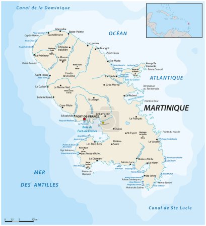
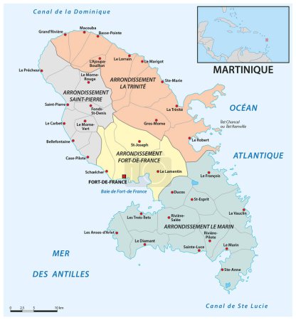
38 Vektoren zum Thema "martinique political map" bei ClipDealer

Medien sortieren nach     Gehe zu Seite:    
« Vorherige  1  Nächste »
Windward Islands political map. Islands of the Lesser Antilles, south of the Leeward Islands in the Caribbean Sea. From Dominica, Martinique, Saint Lucia, Saint Vincent and the Grenadines, to Grenada.
Lesser Antilles political map
Grenada Political Map
Lesser Antilles political map
Dominica Political Map
Martinique Political Map
Guadeloupe, Dominica and Martinique political map
Eastern Caribbean islands, gray political map. Puerto Rico, Virgin Islands, Leeward and Windward Islands, and part of the Leeward Antilles north the coast of Venezuela, located in the Caribbean Sea.
Volcanoes of the Caribbean islands, political map. Map of crescent-shaped island arc of Lesser Antilles, showing potentially active volcanoes, of which the best known is Mount Pelee in Martinique.
Lesser Antilles of the Caribbean, multicolored political map. Group of islands between Greater Antilles and South America. Divided into the Leeward Islands, Windward Islands, and the Leeward Antilles.
Eastern Caribbean islands, political map. Puerto Rico, Virgin Islands, Leeward and Windward Islands, and part of the Leeward Antilles north the coast of Venezuela, all located in the Caribbean Sea.
Detailed map of the overseas French regions of Martinique, Guadeloupe, Mayotte, French Guiana, and La Reunion (France) with borders of municipalities, subdistricts (cantons), districts (arrondissements), departments (departements), and region
Martinique vector map. Editable template with regions, cities, red pins and blue surface on white background.
Map of Martinique
France map, new regions
Martinique map with borders, cities, capital and administrative divisions. Infographic vector map. Editable layers clearly labeled.
Martinique vector map with infographic elements, pointer marks.
Caribbean islands map with names vector
Beautiful and colorful detailes map of France with french islands, new regions and capitals. French names. Vector illustration II.
Vector color detailed map of metropolis and overseas territories of France  with administrative divisions of the country, each region is presented separately in-highly detailed and divided into departments
Beautiful and colorful detailes map of France with french islands, new regions and capitals. French names. Vector illustration.
Detailed map of metropolis and overseas territories of France with administrative divisions into regions and departments, large cities of the country, vector illustration on a white background
Administrative map of the 13 regions of France and overseas territories
Blue-gray detailed map of Dominica administrative divisions and location on the globe. Vector illustration
Beautiful and colorful detailes map of France with french islands, new regions and capitals. French names. Vector illustration III.
Detailed vector map of Martinique and capital city Fort-de-France
Illustration of departments of France
Map of french overseas region Martinique combined with french national flag.
Martinique flag, official colors and proportion. Vector illustration.
Carriacou and Petite Martinique map, administrative division of Grenada. Vector illustration.
Vector map of the Caribbean island of Martinique, France
Grenada map with administrative divisions. Vector illustration.
Carriacou and Petite Martinique map, administrative division of Grenada. Vector illustration.
Grenada map with administrative divisions. Vector illustration.
Map of Department of Martinique, vector illustration
Carriacou and Petite Martinique map, administrative division of Grenada. Vector illustration.
Grenada map with administrative divisions. Vector illustration.
Administrative map of the Caribbean island of Martinique, France

« Vorherige  1  Nächste »