Robotic hand pointing, mail envelope, and upwa ...

Robotic hand pointing, mail envelope, and upward arrows. Ideal for automation, email, AI, communication, robotics progress futuristic technology. Flat simple metaphor

Media-ID: B:795860398
Nutzungsrecht: Kommerzielle und redaktionelle Nutzung

Robotic hand pointing, mail envelope, and upward arrows. Ideal for automation, email, AI, communication, robotics progress futuristic technology. Flat simple metaphor

Vorschau      
  • Varianten

  • Mediainfos

Dieses Bild mit unserem Kundenkonto ab £0.83 herunterladen!
Standardlizenz: EPS
Format Bildgröße Downloads  
Vektorgrafik eps 1
Standardlizenz: JPG
Format Bildgröße Netto Brutto Preis
Web S
0.5 MP
500x489 Pixel
16.93x16.56 cm (75 dpi)
£3.39 £3.63
Print M
2 MP
1000x978 Pixel
8.47x8.28 cm (300 dpi)
£6.00 £6.42
Print XL
8 MP
2000x1955 Pixel
16.93x16.55 cm (300 dpi)
£11.22 £12.01
Print XXL
15 MP
5000x4888 Pixel
42.33x41.39 cm (300 dpi)
£13.83 £14.80
Standardlizenz: EPS
Format Bildgröße Netto Brutto Preis
Vektorgrafik eps £8.61 £9.21
Merchandisinglizenz: EPS
Format Bildgröße Netto Brutto Preis
Vektorgrafik eps £69.51 £74.38
Media-ID: B:795860398
Aufrufe: 1
   
Beschreibung: Robotic hand pointing, mail envelope, and upward arrows. Ideal for automation, email, AI, communication, robotics progress futuristic technology. Flat simple metaphor

Nutzungslizenz

Nutzungsrecht: Kommerzielle und redaktionelle Nutzung

Userinfos

Hinzugefügt von: robuart
Weitere Medien von robuart

Bewertung

Bewertung:
Bewertungen: 0 / Durchschnitt: 0

Ähnliche lizenzfreie Vektorgrafiken

Malta Political Map
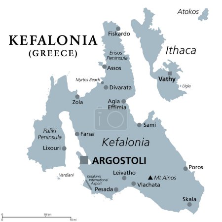
Kefalonia, Greek island, gray political map. Also known as Cephalonia, Kefallinia or Kephallenia. The largest Ionian Island, located in western Greece and in the Ionian Sea, with capital Argostoli.
Santorini, an island of Greece, gray political map. Officially Thira and classical Greek Thera. Archipelago and remnant of a caldera in the Aegean Sea, and the southernmost member of the Cyclades.
Guadeloupe political map
Madeira Islands political map
Aegadian Islands, Favignana, Levanzo, Marettimo, political map. Group of five small mountainous islands in the Mediterranean Sea off the coast of Sicily, Italy, near the cities of Trapani and Marsala.
Elba, political map, Mediterranean island in Tuscany, Italy, with capital Portoferraio. Located in the Tyrrhenian Sea and largest island in the Tuscan Archipelago. Site of the first exile of Napoleon.
Montenegro political map
Kefalonia, Greek island, political map. Also known as Cephalonia, Kefallinia or Kephallenia, the largest Ionian Island, located in western Greece and in the Ionian Sea, with capital Argostoli. Vector.
Gibraltar political map
Anguilla, Saint-Martin, Sint Maarten and Saint Barthelemy political map
Estonia political map
Monaco Political Map
Estonia Political Map
Macedonia region, political map. Region of the Balkan Peninsula in Southeast Europe. Part of Greece, North Macedonia, Bulgaria, Albania, Kosovo and Serbia. English labeling. Illustration. Vector.
Monaco, Nice and Cannes, political map. The coastal strip of Alpes-Maritimes, a department of France, located on the French Riviera and Mediterranean Sea. With the microstate Principality of Monaco.
Kosovo political map with capital Pristina
Albania political map
Lefkada, regional unit, political map. Part of the Ionian Islands in Greece, also known as Lefkas, Leukas or Leucadia. With Tilevoides Islands Meganisi, Kalamos, Kastos, Skorpios and smaller islets.
Saint-Martin Country Political Map